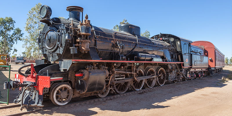
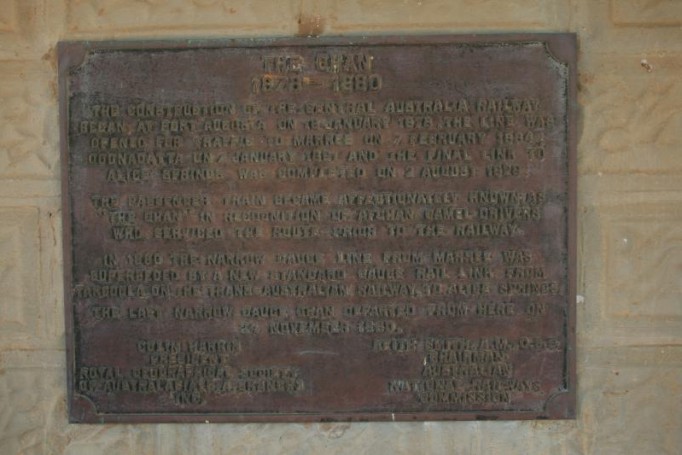
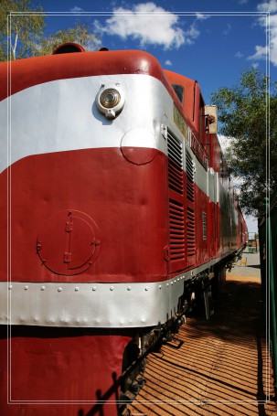
old ghan train
6225192459_1863e9ac5c_k
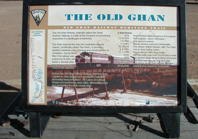
Old Ghan Railway
4940463733_31ce88ad29_k
Beresford Siding on the Old Ghan Railway, along the Oodnadatta Tk. SA
Beresford Siding on the Old Ghan Railway.
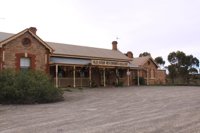
Old Ghan Restaurant, Hawker
This used to be a railway station on the old Ghan route, now a restaurant.
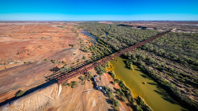
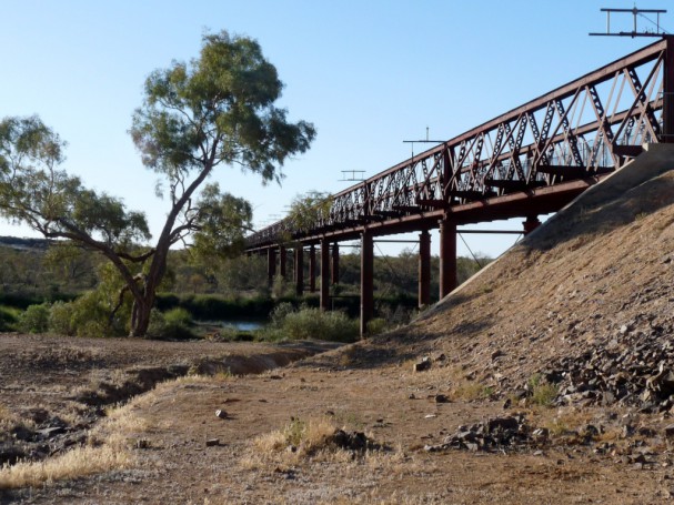
Algebuckina Bridge
The Algebuckina Bridge of the Old Ghan Railway over the Neales River on Oodnadatta Track in SA. Built in the 1880s this spectacular wrought iron bridge carried the former Alice Springs narrow gauge railway across the flood plain of the River Neales. After a severe flood in 1974, which almost reached the bridge decks, the line was closed in 1981 and a new route built 100 miles further west.
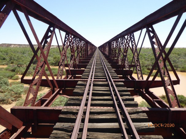
Algebuckina Bridge
Old Ghan railway crossing of the Neales River on Allendale Station..
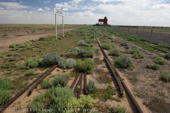
Curdimurka Siding on the Old Ghan line along the Oodnadatta Tk.
Water tank and desalination tank were used to supply water to the steam locos used on the Old Ghan.
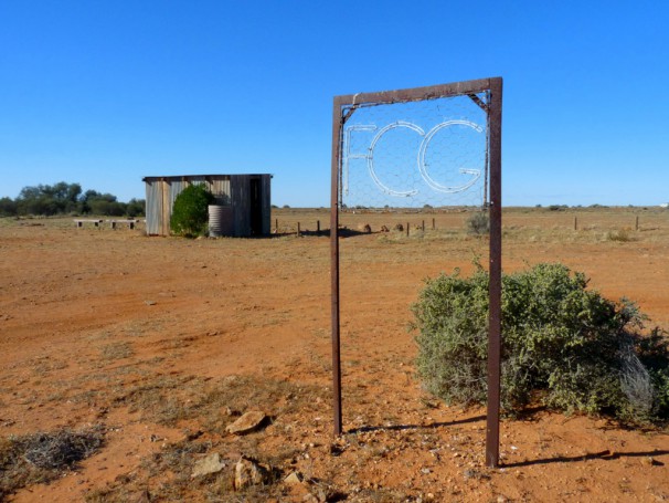
The old Ghan sign
P8080179

Evening collection on a fence. The old C3040Z still takes nice images.
OLYMPUS DIGITAL CAMERA still a good camera!
Exposure Time: 1/320
F-stop: f/1.8 It has a fast lens!
ISO Speed: 100
Focal Length: 8.40
Exposure Bias: 7/10
Exposure Program: Aperture priority
Metering Mode: Spot
Flash:
Flash Fired: False
Flash Function: False
Flash Mode: 0
Flash Red Eye Mode: False
Flash Return: 0
Light Source: Unknown
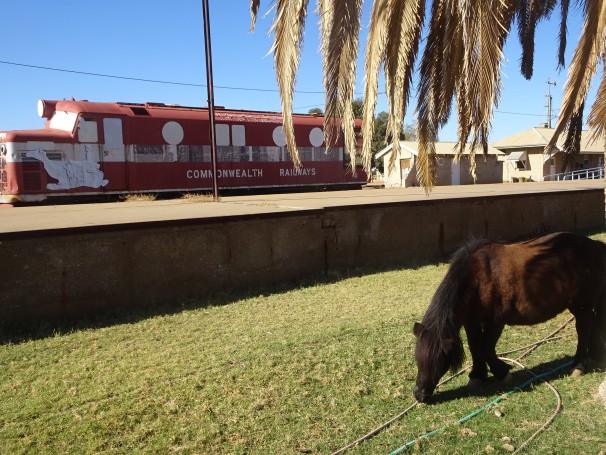
Marree. The disused railway station. The Old Ghan train to Alce Springs left from here. Grazing horse.
Marree/Herrgott Springs. Population 65. These semi desert Aboriginal lands were first sighted by white men in 1840 when Edward John Eyre and his exploration party reached Lake Eyre. For some time people thought Lake Torrens and Lake Eyre was one big inland sea but explorations by Surveyor General George Goyder in 1860 proved that the lakes were separate. At that time Governor MacDonnell named the lake after explorer Eyre (now Kati Thanda). It is about 90 kms from Marree. This area of SA is underpinned by deep artesian waters contained under great pressure and in some places they bubble to the surface forming springs. Salts and other minerals from the saline waters eventually create calcium walls around the springs as the water evaporates hence the term mound springs. When Sir Charles Todd was heading the construction of the Overland Telegraph in 1870- 1872 from Port Augusta to Darwin a camp was located at Herrgott Springs which was the first European name for the site of Marree. It was named after explorer John McDougall Stuart‘s botanist Joseph Herrgott who discovered a mound spring in 1859. There are over 5,000 mound springs in SA and they were vital to the construction of the Overland Telegraph.
The town emerged when the Great Northern Railway reached Herrgott Springs in 1884. Before the survey a hotel and a general store opened in 1882.From the beginning the locals and towns people called the place Marree but the government railway station was Herrgott Springs. The Police Station and Post Office opened in 1883 and the school in 1884. During World War One this German name was changed to Marree in line with previous local usage. By 1885 the town had the two storey Great Northern Hotel, two general stores, two butchers, three saddlers and an iron Wesleyan Methodist church and it had 600 residents. This church was used as the government school which was only built in 1908. The Post Office began in a tent until a building was erected in 1886 and it doubled as a repeater station for the Overland Telegraph. The Marree hospital opened in 1912. The railway was the focus of the early town and in 1891 there was a government survey to see if a railway line from Marree up the Birdsville was viable. Another survey was undertaken in 1916 but nothing eventuated. Supplies went up and down to Birdsville by camel trains
Many Afghan cameleers were based at the springs as this was the starting point for camel trains to Birdsville, Oodnadatta and elsewhere. Around 1900 about 1,500 camels were based in Marree with 800 owned by just one Afghan. Although motor transport developed in the 1920s the Birdsville track cameleers were in Marree until 1949. Recently a replica Muslim mosque has been erected in the town to commemorate the role the Afghans played in servicing the Birdsville track. The first Mosque open by 1884 and was replaced twice before it closed. Its prayer rugs were sent to the Gilbert St. Mosque in Adelaide. Afghan names in Marree included Dervish, Moosha, Khan, Balook, Wahub, Dadih, Goolamdeen etc. Tom Kruse ran a truck mail service to Birdsville from 1936 to 1963 although the service continued until 1975 when an air service took over. 300 or so date palms were planted in Marree as a trial in 1884 but they did not thrive after about 30 years. The new standard gauge railway to Marree opened in 1957 employing about 85 men as the Ghan to Alice Springs changed gauge here from standard to the narrow 3’6” gauge. This railway closed in 1980 and the town has declined but tourism keeps it alive. Marree has a population of about 100 of which 60 % are men so it is a great place for women to find a partner! Marree Aboriginal School has two primary and one secondary class and six part time teachers. The town also has a Royal Flying Doctor service office, old Commonwealth Railway deserted train engines, and one of the trucks used by Tom Kruse from 1936. When the railway reached Marree in 1884 the town grew and by around the turn of the century the railway divided the town racially with the Europeans on the side with the hotel, the school, the Police Station and the Afghan cameleers and the Djeri Aboriginals on the other side. This is no longer the case as the Afghan cameleers are gone and few Europeans live in Maree these days.
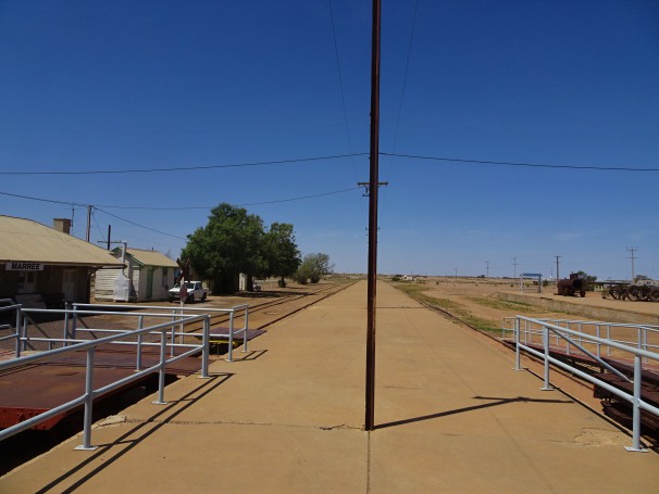
Marree. The platform of the disused railway station. Station building on the left. This was used by the old Ghan train service to Alice Springs from 1929 to 1980.
Marree/Herrgott Springs.
These semi desert Aboriginal lands were first sighted by white men in 1840 when Edward John Eyre and his exploration party reached Lake Eyre. For some time people thought Lake Torrens and Lake Eyre was one big inland sea but explorations by Surveyor General George Goyder in 1860 proved that the lakes were separate. At that time Governor MacDonnell named the lake after Eyre (now Kati Thanda). It is about 90 kms from Marree. This area of SA is underpinned by deep artesian waters contained under great pressure and in some places they bubble to the surface forming springs. Salts and other minerals from the saline waters eventually create calcium walls around the springs as the water evaporates hence the term mound springs. When Sir Charles Todd was heading the construction of the Overland Telegraph in 1870- 1872 from Port Augusta to Darwin a camp was located at Herrgott Springs which was the first European name for the site of Marree. It was named after explorer John McDougall Stuart‘s botanist Joseph Herrgott who discovered a mound spring in 1859. There are over 5,000 mound springs in SA and they were vital to the construction of the Overland Telegraph.
The town emerged when the Great Northern Railway reached Herrgott Springs in 1884. Before the survey a hotel and a general store opened in 1882.From the beginning the locals and towns people called the place Marree but the government railway station was Herrgott Springs. The Police Station and Post Office opened in 1883 and the school in 1884. During World War One this German name was changed to Marree in line with previous local usage. By 1885 the town had the two storey Great Northern Hotel, two general stores, two butchers, three saddlers and an iron Wesleyan Methodist church and it had 600 residents. This church was used as the government school which was only built in 1908. The Post Office began in a tent until a building was erected in 1886 and it doubled as a repeater station for the Overland Telegraph. The Marree hospital opened in 1912. The railway was the focus of the early town and in 1891 there was a government survey to see if a railway line from Marree up the Birdsville was viable. Another survey was undertaken in 1916 but nothing eventuated. Supples went up and down to Birdsville by camel trains
Many Afghan cameleers were based at the springs as this was the starting point for camel trains to Birdsville, Oodnadatta and elsewhere. Around 1900 about 1,500 camels were based in Marree with 800 owned by just one Afghan. Although motor transport developed in the 1920s the Birdsville track cameleers were in Marree until 1949. Recently a replica Muslim mosque has been erected in the town to commemorate the role the Afghans played in servicing the Birdsville track. The first Mosque open by 1884 and was replaced twice before it closed. Its prayer rugs were sent to the Gilbert St. Mosque in Adelaide. Afghan names in Marree included Dervish, Moosha, Khan, Balook, Wahub, Dadih, Goolamdeen etc. Tom Kruse ran a truck mail service to Birdsville from 1936 to 1963 although the service continued until 1975 when an air service took over. 300 or so date palms were planted in Marree as a trial in 1884 but they did not thrive after about 30 years. The new standard gauge railway to Marree opened in 1957 employing about 85 men as the Ghan to Alice Springs changed gauge here from standard to the narrow 3’6” gauge. This railway closed in 1980 and the town has declined but tourism keeps it alive. Marree has a population of about 100 of which 60 % are men so it is a great place for women to find a partner! Marree Aboriginal School has two primary and one secondary class and six part time teachers. The town also has a Royal Flying Doctor service office, old Commonwealth Railway deserted train engines, and one of the trucks used by Tom Kruse from 1936.
27-old ghan train station
10084508664_7b36a93dd7_k
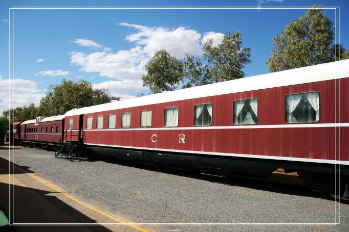
Marree, Old Ghan Station
3479891786_b51568b0ec_c
28-old ghan train station
10084642283_87c5034cb4_k
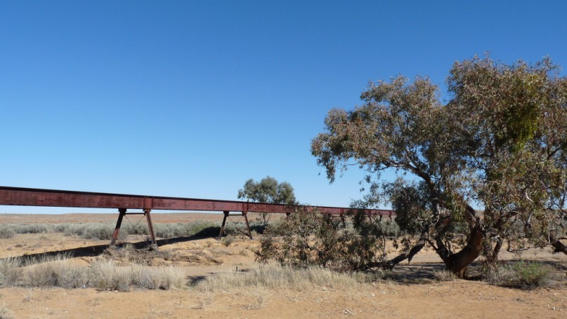
The largrest Old Ghan Rail Bridge
8035028672_69166dd3ec_c
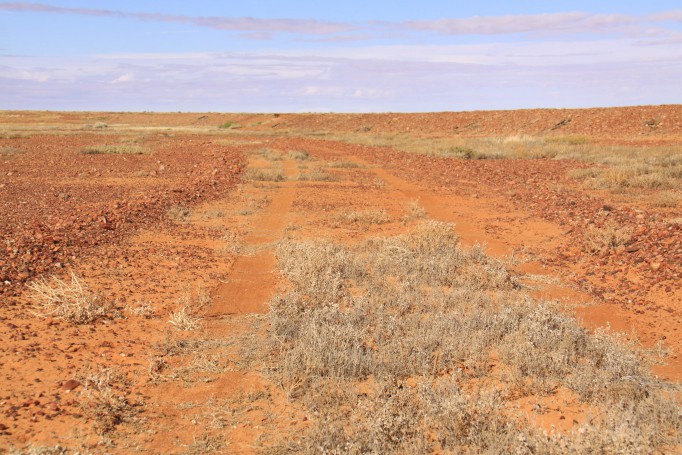
Oodnadatta Track
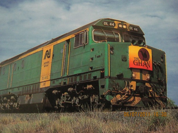
Old Ghan railway line
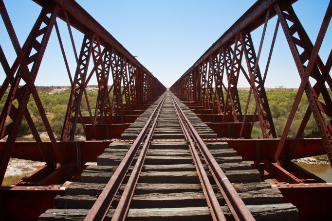
Algebuckina Bridge
Algebuckina Bridge is probably THE outback railway bridge. Located close to the Oodnadatta track it is a remainder of the Old Ghan railway and with 578m the longest span bridge on the Old Ghan.
Lyndhurst
Old Ghan railway line
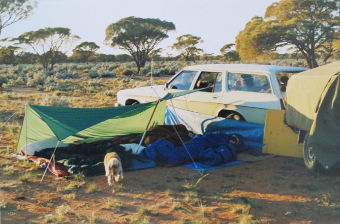
camp with the #HJHolden1975 on the NW end of the Oodnadatta Track
On our way to Uluru with Trudy and the kids.
We got to Ayers Rock the next day, via Ebenezer, views of Mt Connor from a sand dune with Trudy, the dog, then a visit to Sunset Strip for photos before making camp in the Ayers Rock campground, where we saw a dingo licking down the BBQs.
We popped down a few Km along the track for the night to get away from the trucks on the Stuart Highway at Marla.
It was a pleasant spot with no noise or passing cars.
We never thought we would head down this road again 20 years later, and travel most of the road a few times, once again in the HJ, and then a few times to see Lake Eyre in the Landcruiser, Smoky.
See a good description of what there is to see along the track.
From www.westprint.com.au. Oct 2016
Friday Forum
Editor’s comments are in green.
Trip Notes – Oodnadatta Track, South Australia.
Went from Maree to Oodnadatta this week. Best camp Farina by far. Best view Lake Eyre from lookout. Best experience- Arkaringa sunup and sundown. Best Tip- Flynet. Russ
Oodnadatta track – good news is that the Marree man has reappeared. Andrew
www.expeditionaustralia.com.au/2016/08/marree-man-geoglyp...
With tracks drying out, it will be back to good driving conditions and if you want to include a link to my Blog when we were out there in August, it will give him and other viewers just what there is to see along this great drive. Stephen.
www.exploroz.com/Members/58567.500/9/2016/Oodnadatta_Trac...
We travelled the Oodnadatta Track in August this year, just before the recent rain. We were in our Patrol and towing an off-road camper trailer. Before the rain, the track was in very good condition and we enjoyed comfortable travel at about 80 kph.
And there is lots to look out for, but most of it is easily spotted from the road. Here are some highlights listed below.
First there is Farina – between Lyndhurst and Marree. Farina was a small township on the Old Ghan Railway line. Now in ruins, the Farina Restoration Group is slowly restoring the old buildings to prevent further decay. The Restoration Group has also placed informative signs around the old township. The ruins are on Farina Station and there is a very nice campground in the dry creek bed there.
Marree is an interesting old town with a fine hotel and railway station. There are narrow gauge diesels and Tom Cruse’s old truck also at the station. You can get fuel and other supplies from the general store and some of the best homemade pasties going.
Further along the track is Plane Henge. You will notice this from a long way off due to the unusual shapes appearing on the horizon. This is a sculpture park and worth a look at some of the unusual shapes and forms that have appeared here over time. There is also inventive use of existing structures, including the railway water tank that now looks like a dog.
Lake Eyre South is next, and a lookout has been provided, via a turn off to the right, with a good view of the lake – which is mostly dry.
Curdimurka Siding, was a former station for the railway line and is the next lump to appear on the horizon. As the most intact of the rail buildings not in a township, this is also worthy of a stop off. As well as the main building, there are a couple of tin sheds and rail tracks heading north to the decaying water tank and desalination tower. If you go past the water tank following the rail tracks will bring you to a bridge over Stuart Creek. There was a waterhole here when we were there with black swans, herons and ducks present.
The Wabma Kadarbu Mound Springs, this time to the left of the road and along a rougher track, is another point of much interest. There are parking areas and board walks across sensitive ground to Blanche Cup and the Bubbler.
Back on the Track and Coward Springs is only a short distance away. This is another camping ground on station property, set in amongst some large casuarinas with all amenities of toilets, donkey powered hot showers and natural spa for something quite different. There are a couple of old buildings from the railway era too.
Another interesting stop off is Strangways Springs, via a turnoff on the left side of the Track, which is marked by a Pink Roadhouse sign. Here are the ruins of a pastoral station and the overland telegraph line. Walking tracks lead to some mound springs and further explores the history of Strangways.
The next stop is William Creek and always worthy of a stopover. There is the pub, an airstrip for scenic flights over Lake Eyre, an outdoor museum and a pleasant camp ground with all amenities.
At Algebuckina, the impressive railway bridge spans the Neales River. With an overall length of 578 metres it is the longest bridge in South Australia. There is also nice camping along the waterhole here.
And finally, Oodnadatta, where you will find the Pink Roadhouse, the Transcontinental Hotel and the old railway station building, which is now a museum housing a very interesting pictorial display. Ask at the Roadhouse for a key to view the museum.
There are several other railway or telegraph related ruins accessible from or close to the Track. The Oodnadatta Track might seem like it crosses a flat, featureless plain, but there is plenty to see along the way.
Coward Springs Campground is a must-stay along the Oodnadatta Track. Once a station on the old Ghan railway line, the site was constructed in 1888 and abandoned before the line was closed in 1980. Greg Emmett and Prue Coulls have been here as your resident hosts since 1991. They have built facilities, planted hundreds of locally native trees, restored the heritage buildings and much more. In 1998 the site (which includes two houses, two in-ground rainwater tanks, a bore, date palms and athel pines) was added to the South Australian Heritage Register. Well worth a stop even just for a day visit to the ‘natural spa’. Jenny.
We were up that way the end of August on the way to do the Madigan, which we had to cancel due to all the rain.
There has been a lot of rain out there and parts of the track have been closed on and off for the last couple of months so the first thing to do is check road conditions. This can be done by checking the SA Outback Roads condition report. Just google it. Alternatively, you can call the Pink Roadhouse for info. I would also check the forthcoming weather forecast by any of the reputable Apps that use the BOM as their source
As this is a very frequently used track I would imagine the graders have been out after the recent rains? If so I think it would be in good gravel road conditions.
As for places you must see, the best bet is to go to the Pink Roadhouse website and follow the link to Mud Maps, where there are a whole host of mud maps put together by the late Adam Plate, prior proprietor of the Roadhouse.
From my perspective, things to see are
Lake Eyre ...... If it is close to full, or you won't see any water from the edge.
Algebuckina Bridge. This is on the side of the track with plenty of places to camp up
Old Peake telegraph station ruins and copper mine ruins. Although this is about 20k off the track it will take 45 mins to get out there. You can camp here but there is limited space.
Coward Springs is worth a stop to see the old Railway Station. You can also camp there for a fee.
At the top end, it's worth heading for Dalhousie Springs to experience the hot thermal spring in the Witjira NP. Entry and camping fees apply unless you have a valid SA Desert Parks pass.
When we were at Dalhousie end of August, we managed to get out to Mt Dare on the day the track was closed. This means the track to and out of Mt Dare was becoming badly cut up. It may be wise to check with Mt Dare and SA Parks to see if the track has been graded since. Otherwise, if it is open, it will be badly rutted.
Malcolm and Trish
Oodnadatta Track
Old Ghan railway line
Farina Cricket Club
Old Ghan railway line
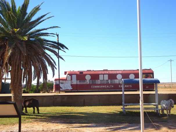
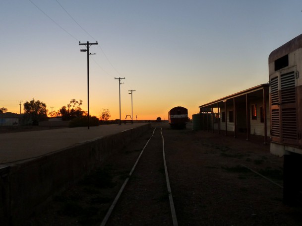
Marree. The Commonwealth Railways railway station where the old Ghan began to Alice Springs.
Marree/Herrgott Springs. Population 65. These semi desert Aboriginal lands were first sighted by white men in 1840 when Edward John Eyre and his exploration party reached Lake Eyre. For some time people thought Lake Torrens and Lake Eyre was one big inland sea but explorations by Surveyor General George Goyder in 1860 proved that the lakes were separate. At that time Governor MacDonnell named the lake after explorer Eyre (now Kati Thanda). It is about 90 kms from Marree. This area of SA is underpinned by deep artesian waters contained under great pressure and in some places they bubble to the surface forming springs. Salts and other minerals from the saline waters eventually create calcium walls around the springs as the water evaporates hence the term mound springs. When Sir Charles Todd was heading the construction of the Overland Telegraph in 1870- 1872 from Port Augusta to Darwin a camp was located at Herrgott Springs which was the first European name for the site of Marree. It was named after explorer John McDougall Stuart‘s botanist Joseph Herrgott who discovered a mound spring in 1859. There are over 5,000 mound springs in SA and they were vital to the construction of the Overland Telegraph.
The town emerged when the Great Northern Railway reached Herrgott Springs in 1884. Before the survey a hotel and a general store opened in 1882.From the beginning the locals and towns people called the place Marree but the government railway station was Herrgott Springs. The Police Station and Post Office opened in 1883 and the school in 1884. During World War One this German name was changed to Marree in line with previous local usage. By 1885 the town had the two storey Great Northern Hotel, two general stores, two butchers, three saddlers and an iron Wesleyan Methodist church and it had 600 residents. This church was used as the government school which was only built in 1908. The Post Office began in a tent until a building was erected in 1886 and it doubled as a repeater station for the Overland Telegraph. The Marree hospital opened in 1912. The railway was the focus of the early town and in 1891 there was a government survey to see if a railway line from Marree up the Birdsville was viable. Another survey was undertaken in 1916 but nothing eventuated. Supplies went up and down to Birdsville by camel trains
Many Afghan cameleers were based at the springs as this was the starting point for camel trains to Birdsville, Oodnadatta and elsewhere. Around 1900 about 1,500 camels were based in Marree with 800 owned by just one Afghan. Although motor transport developed in the 1920s the Birdsville track cameleers were in Marree until 1949. Recently a replica Muslim mosque has been erected in the town to commemorate the role the Afghans played in servicing the Birdsville track. The first Mosque open by 1884 and was replaced twice before it closed. Its prayer rugs were sent to the Gilbert St. Mosque in Adelaide. Afghan names in Marree included Dervish, Moosha, Khan, Balook, Wahub, Dadih, Goolamdeen etc. Tom Kruse ran a truck mail service to Birdsville from 1936 to 1963 although the service continued until 1975 when an air service took over. 300 or so date palms were planted in Marree as a trial in 1884 but they did not thrive after about 30 years. The new standard gauge railway to Marree opened in 1957 employing about 85 men as the Ghan to Alice Springs changed gauge here from standard to the narrow 3’6” gauge. This railway closed in 1980 and the town has declined but tourism keeps it alive. Marree has a population of about 100 of which 60 % are men so it is a great place for women to find a partner! Marree Aboriginal School has two primary and one secondary class and six part time teachers. The town also has a Royal Flying Doctor service office, old Commonwealth Railway deserted train engines, and one of the trucks used by Tom Kruse from 1936. When the railway reached Marree in 1884 the town grew and by around the turn of the century the railway divided the town racially with the Europeans on the side with the hotel, the school, the Police Station and the Afghan cameleers and the Djeri Aboriginals on the other side. This is no longer the case as the Afghan cameleers are gone and few Europeans live in Maree these days.
24-old ghan train station
10084566285_aa6849c3a2_k
26-old ghan train station
10084647403_77c5b082ee_k
Oodnadatta Track, Maree
Old Ghan railway line, Maree

 English